Brookings Area Transportation Plan
About the Brookings ATP
The Brookings Area Transportation Plan (BATP) will be a roadmap with recommendations and guidelines for the future development of transportation infrastructure such as roads, bike lanes and walking paths in the community. The plan will assess current conditions to figure out where we are and where we should go.
Since the previous transportation plan was adopted in 2011, the City of Brookings has grown by 9% in population and expanded its footprint by 4%. Additionally, a new interchange with Interstate 29 has been constructed at 20th Street South, changing the landscape of transportation in the area. With continued growth and future development on the horizon, updating the transportation plan is essential to ensure the area's infrastructure can support the economic and social well-being of its residents.

In the process of updating the transportation plan, we will gather input from the public and community stakeholders to evaluate the current and future needs of key roadways, including airport, transit, freight, pedestrian and bicycle infrastructure. The plan update will identify areas for improvement and prioritize projects based on their urgency-short-term, mid-term and long-term-while also considering available funding options. Ultimately, refreshing this transportation plan will provide a strategic framework to guide the area's transportation infrastructure, help to address current challenges and plan for sustainable growth and mobility in the years to come.
This Plan is a collaborative effort between the City of Brookings, City of Aurora, Brookings County, South Dakota Department of Transportation (SDDOT), other surrounding communities, the public and study stakeholders.
Study Objectives
The Brookings Area Transportation Plan will outline a set of recommended improvements to meet the area's projected transportation demands and promote a livable community that will enhance the social and economic well-being of Brookings area residents and preserve the social environmental character of the region. Key elements of the update include:
- Identify current and potential transportation issues and needs facing the Brookings area.
- Develop feasible solutions that meet current design standards and/or traffic level of service and safety expectations.
- Create final products for the City of Brookings, City of Aurora, Brookings County, and the South Dakota Department of Transportation that offer guidance on implementing recommended improvements and proactively integrate future development plans within the area.
Transportation Plan Area
Click to enlarge
- Study area is a rectangular area with the yellow tint. The northern boundary is between 207th and 208th streets. The southern boundary is between 217th and 218th streets. The western boundary is between 465th and 466th avenue. The eastern boundary is between 476th and 477th Avenue.
- City limits are shown in gray for the cities of Brookings, Volga, Aurora and Bushnell
- Parks and greenspaces are shown in a green color.
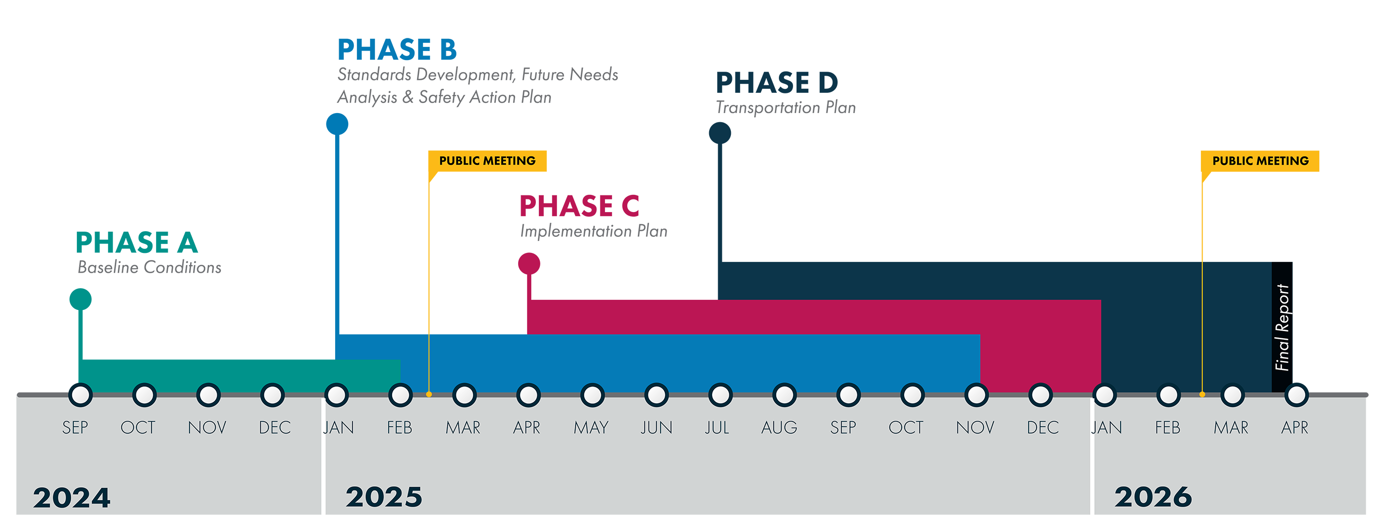
Transportation Plan Timeline
Click to enlarge
- Phase A: Baseline Conditions (September 2024 to February 2025)
- Phase B: Standards Development, Future Needs Analysis & Safety Action Plan (January to November 2025)
- Public Meeting takes place in February
- Phase C: Implementation Plan (April to January 2026)
- Phase D: Transportation Plan (July to April 2026)
- Public Meeting takes place in February
- Final Report in April 2026/li>

